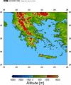
Map of Garmisch-Partenkirchen (47.48°N, 11.07°E)
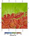 This kind of map is required as input for the 3D Monte Carlo model which was used
e.g. for [Kylling et al., 1999].
As an example, an area of 201 x 201 km² is being used as model input with a
pixel size of 1 x 1 km², where the site under consideration is the center pixel.
The map shown here is a combination of the coastlines, rivers, and political
boundary data set which comes which GMT, and the
GTOPO30 topography data. The
GTOPO30 data were extracted using grdraster. The coodinates of the corners of
the 201 x 201 km² large area were determined using mapproject.
A general stereographic projection was chosen for the creation of the map.
This kind of map is required as input for the 3D Monte Carlo model which was used
e.g. for [Kylling et al., 1999].
As an example, an area of 201 x 201 km² is being used as model input with a
pixel size of 1 x 1 km², where the site under consideration is the center pixel.
The map shown here is a combination of the coastlines, rivers, and political
boundary data set which comes which GMT, and the
GTOPO30 topography data. The
GTOPO30 data were extracted using grdraster. The coodinates of the corners of
the 201 x 201 km² large area were determined using mapproject.
A general stereographic projection was chosen for the creation of the map.
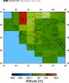
Topographic map and albedo distribution of Tromsoe
(69.65°N, 18.95°E)
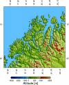
 These three maps show the data which were used as input for
[Kylling et al., 1999]. Both, topography
and surface albedo were defined on a 1 x 1 km² grid, and the model domain
was 201 x 201 km².
For the simulations, it was assumed that the
land was completely covered by snow (albedo 0.8) while the sea was completely
snow free (albedo 0.07). Otherwise, the maps were created as described in the
example above.
These three maps show the data which were used as input for
[Kylling et al., 1999]. Both, topography
and surface albedo were defined on a 1 x 1 km² grid, and the model domain
was 201 x 201 km².
For the simulations, it was assumed that the
land was completely covered by snow (albedo 0.8) while the sea was completely
snow free (albedo 0.07). Otherwise, the maps were created as described in the
example above.
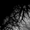
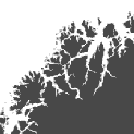
Global Topographic Data
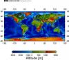
 These three maps show a global topographic data set which has been
created from the
TerrainBase data (resolution: 5 arc minutes,
download here).
About 240 MBytes of ASCII data on the original resolution are required
to create the left map. The middle and right map are a subset of
the complete data set, on the original resolution (middle) and degraded to
1.25° x 1° (right), corresponding to the size of the
TOMS pixel.
These three maps show a global topographic data set which has been
created from the
TerrainBase data (resolution: 5 arc minutes,
download here).
About 240 MBytes of ASCII data on the original resolution are required
to create the left map. The middle and right map are a subset of
the complete data set, on the original resolution (middle) and degraded to
1.25° x 1° (right), corresponding to the size of the
TOMS pixel.
Download the
high resolution topographic data (5 arc minutes)
(ATTENTION: 240 MBytes uncompressed, 28 MBytes compressed) or the
low resolution data (TOMS resolution). To do that,
Right-Click on the links to "Save Link As" on your harddisk.
The file format is ASCII.
The three columns are
- Longitude [degrees], West negative
- Latitude [degrees], South negative
- Elevation [m]
The data have been clipped at Elevation = 0 to get the ocean surface
rather than the ocean bottom.